 气候变化:创纪录的飓风是什么样子的?
climate change: What a record-breaking hurricane looks like
译文简介
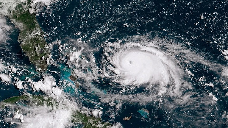
飓风“李”在24小时内从一级风暴升级为五级飓风。专家表示,这样的风暴更有可能发生在一个变暖的世界。
正文翻译
Hurricane Lee grew from a category one storm to a category five hurricane in 24 hours. Experts say such storms are more likely in a warming world.
飓风“李”在24小时内从一级风暴升级为五级飓风。专家表示,这样的风暴更有可能发生在一个变暖的世界。
原创翻译:龙腾网 https://www.ltaaa.cn 转载请注明出处
As Hurricane Lee brought large swells and ferocious winds to batter the Caribbean islands, experts said the storm – which quickly and unexpectedly intensified into the highest category five strength – could be a sign of what's to come as the world's oceans warm up.
随着飓风“李”带来的巨浪和狂风袭击加勒比海岛屿,专家们表示,这场风暴迅速出人意料地增强到最高的五级强度,可能是世界海洋变暖即将到来的一个迹象。
原创翻译:龙腾网 https://www.ltaaa.cn 转载请注明出处
随着飓风“李”带来的巨浪和狂风袭击加勒比海岛屿,专家们表示,这场风暴迅速出人意料地增强到最高的五级强度,可能是世界海洋变暖即将到来的一个迹象。
原创翻译:龙腾网 https://www.ltaaa.cn 转载请注明出处
The hurricane, which reached 160mph (258km/h) winds on Friday (8 September), was a category one storm on Thursday but intensified to a category five, increasing by 85mph (137km/h) in just 24 hours. The increase made the hurricane, which meteorologists dubbed "rare", the third-fastest rapid intensification in the Atlantic. According to the National Oceanic and Atmospheric Administration (NOAA), the definition of rapid intensification is a 35mph (56km/h) over a one-day period – which Lee greatly exceeded.
飓风在周五(9月8日)风速达到160英里/小时(258公里/小时),周四为一级风暴,但在24小时内增强为五级风暴,风速增加了85英里/小时(137公里/小时)。飓风强度的增加使得这场被气象学家称为“罕见”的飓风成为大西洋上第三快的快速增强。根据美国国家海洋和大气管理局(NOAA)的定义,快速强化的定义是在一天内达到35英里/小时(56公里/小时),而李大大超过了这一速度。
飓风在周五(9月8日)风速达到160英里/小时(258公里/小时),周四为一级风暴,但在24小时内增强为五级风暴,风速增加了85英里/小时(137公里/小时)。飓风强度的增加使得这场被气象学家称为“罕见”的飓风成为大西洋上第三快的快速增强。根据美国国家海洋和大气管理局(NOAA)的定义,快速强化的定义是在一天内达到35英里/小时(56公里/小时),而李大大超过了这一速度。
Only two other Atlantic hurricanes in history have intensified more rapidly – Felix in 2007, and Wilma in 2005 – and only 4.5% of named storms in the Atlantic have grown to a category five in the past decade.
历史上只有另外两个大西洋飓风的强度比它更快——2007年的费利克斯和2005年的威尔玛——而且在过去的十年里,大西洋上只有4.5%的风暴达到了五级。
历史上只有另外两个大西洋飓风的强度比它更快——2007年的费利克斯和2005年的威尔玛——而且在过去的十年里,大西洋上只有4.5%的风暴达到了五级。
Some climate scientists were stunned over not just Lee's sudden intensification – and then rapid weakening – but also the timing of Jova, which rapidly ballooned into a category five storm as it made its way over the Pacific Ocean at the same time Lee was forming. These two huge storms formed as the US Atlantic hurricane season peaked on 10 September.
一些气候科学家不仅对“李”的突然增强——然后迅速减弱——感到震惊,而且对“约瓦”形成的时间也感到震惊。在“李”形成的同时,“约瓦”在太平洋上空迅速膨胀为五级风暴。这两个巨大的风暴形成于9月10日美国大西洋飓风季的高峰。
原创翻译:龙腾网 https://www.ltaaa.cn 转载请注明出处
一些气候科学家不仅对“李”的突然增强——然后迅速减弱——感到震惊,而且对“约瓦”形成的时间也感到震惊。在“李”形成的同时,“约瓦”在太平洋上空迅速膨胀为五级风暴。这两个巨大的风暴形成于9月10日美国大西洋飓风季的高峰。
原创翻译:龙腾网 https://www.ltaaa.cn 转载请注明出处
The increase in hurricane intensity is a harbinger of the future, according to Jeff Masters, a meteorologist at Yale Climate Connections (a Yale University-funded climate media forum) and former NOAA scientist. "We should expect more cases of rapid intensification as the climate continues to warm."
飓风强度的增加是未来的预兆,耶鲁气候联系(耶鲁大学资助的气候媒体论坛)的气象学家、前NOAA科学家杰夫·马斯特斯(Jeff Masters)说。“随着气候继续变暖,我们预计会有更多的情况迅速加剧。”
飓风强度的增加是未来的预兆,耶鲁气候联系(耶鲁大学资助的气候媒体论坛)的气象学家、前NOAA科学家杰夫·马斯特斯(Jeff Masters)说。“随着气候继续变暖,我们预计会有更多的情况迅速加剧。”
Hugh Willoughby, research professor at Florida International University's National Hurricane Research Center says a major hurricane intensifying rapidly isn't out of the ordinary, as that's just how they form – and the surprise is these hurricanes are happening during an El Niño.
佛罗里达国际大学国家飓风研究中心的研究教授休·威洛比(Hugh Willoughby)表示,快速增强的大型飓风并不罕见,因为这就是它们形成的方式——令人惊讶的是,这些飓风发生在厄尔尼诺期间。
佛罗里达国际大学国家飓风研究中心的研究教授休·威洛比(Hugh Willoughby)表示,快速增强的大型飓风并不罕见,因为这就是它们形成的方式——令人惊讶的是,这些飓风发生在厄尔尼诺期间。
"What's weird is that there's an El Niño going on, and normally an El Niño is a death on hurricanes – it prevents formation of really nasty hurricanes," he says. "But the conventional wisdom is that this is [still happening] because the ocean is so hot, and that's really interesting."
他说:“奇怪的是,有一个厄尔尼诺正在发生,通常情况下,厄尔尼诺是飓风的死亡——它阻止了真正令人讨厌的飓风的形成。”“但传统观点认为,这种情况(仍在发生)是因为海洋太热了,这真的很有趣。”
原创翻译:龙腾网 https://www.ltaaa.cn 转载请注明出处
他说:“奇怪的是,有一个厄尔尼诺正在发生,通常情况下,厄尔尼诺是飓风的死亡——它阻止了真正令人讨厌的飓风的形成。”“但传统观点认为,这种情况(仍在发生)是因为海洋太热了,这真的很有趣。”
原创翻译:龙腾网 https://www.ltaaa.cn 转载请注明出处
There's "pretty convincing evidence", he adds, that major hurricanes are becoming more common.
他补充说,有“相当令人信服的证据”表明,大型飓风正变得越来越常见。
他补充说,有“相当令人信服的证据”表明,大型飓风正变得越来越常见。
Research has shown the proportion of tropical cyclones that reach category four and five is projected to increase due to global warming. Cyclones – or hurricanes, the term depends on their geographical location – form over warm sea surfaces; as water evaporates off the ocean's surface, it rises as humid air, creating an area of lower air pressure below, causing more air to rush in, which in turn warms and rises. The air that rises eventually cools, forming clouds and thunderstorms, and a system that spins and grows, fed by the ocean's heat and water evaporating from the surface. When wind speeds reach 74mph (119km/h), they're classed as a hurricane or cyclone.
研究表明,由于全球变暖,预计达到4级和5级的热带气旋比例将增加。气旋——或飓风,这个术语取决于它们的地理位置——在温暖的海面上形成;当水从海洋表面蒸发时,它会以潮湿空气的形式上升,在下面形成一个气压较低的区域,导致更多的空气涌入,反过来又变暖并上升。上升的空气最终冷却,形成云和雷暴,以及一个旋转和增长的系统,由海洋的热量和从表面蒸发的水提供能量。当风速达到74英里/小时(119公里/小时)时,就被归类为飓风或气旋。
研究表明,由于全球变暖,预计达到4级和5级的热带气旋比例将增加。气旋——或飓风,这个术语取决于它们的地理位置——在温暖的海面上形成;当水从海洋表面蒸发时,它会以潮湿空气的形式上升,在下面形成一个气压较低的区域,导致更多的空气涌入,反过来又变暖并上升。上升的空气最终冷却,形成云和雷暴,以及一个旋转和增长的系统,由海洋的热量和从表面蒸发的水提供能量。当风速达到74英里/小时(119公里/小时)时,就被归类为飓风或气旋。
Since industrialisation, humans have been fuelling the rapid rise of greenhouse gases, which have increased the frequency and intensity of extreme weather events. And the costs, both on human life and the economy of extreme weather events, are rising.
自工业化以来,人类一直在推动温室气体的迅速增加,这增加了极端天气事件的频率和强度。极端天气事件给人类生命和经济造成的损失正在上升。
自工业化以来,人类一直在推动温室气体的迅速增加,这增加了极端天气事件的频率和强度。极端天气事件给人类生命和经济造成的损失正在上升。
"What we need to worry about are storms that become major hurricanes becoming more frequent and doing more damage," adds Willoughby. "We have every reason to expect them to become more common, and it's going to get worse."
威洛比补充说:“我们需要担心的是,成为主要飓风的风暴会变得更加频繁,造成更大的破坏。”“我们有充分的理由期待它们变得越来越普遍,而且情况会变得更糟。”
威洛比补充说:“我们需要担心的是,成为主要飓风的风暴会变得更加频繁,造成更大的破坏。”“我们有充分的理由期待它们变得越来越普遍,而且情况会变得更糟。”
When hurricanes make landfall they begin to decrease in strength because they no longer gain energy from the ocean. However, they can still wreak devastation. When Hurricane Maria, a category five storm, hit the northeastern Caribbean in 2017, it killed as many as 4,600 people in Puerto Rico alone, causing power cuts, broken roads, and knocking out water services. It was the strongest hurricane to hit the island in a century.
当飓风登陆时,它们的强度开始减弱,因为它们不再从海洋中获得能量。然而,它们仍然可以造成破坏。2017年,当五级飓风玛丽亚袭击加勒比海东北部时,仅在波多黎各就造成多达4600人死亡,造成停电、道路断裂和供水中断。这是一个世纪以来袭击该岛的最强飓风。
当飓风登陆时,它们的强度开始减弱,因为它们不再从海洋中获得能量。然而,它们仍然可以造成破坏。2017年,当五级飓风玛丽亚袭击加勒比海东北部时,仅在波多黎各就造成多达4600人死亡,造成停电、道路断裂和供水中断。这是一个世纪以来袭击该岛的最强飓风。
In the Northwest Pacific, Hurricane Patricia, which hit in 2015, was the strongest landfalling Pacific hurricane on record. It was also the strongest storm in terms of wind speed, with winds of 214mph (345km/h). The death toll, almost unbelievably, was zero. The strongest Atlantic hurricane by wind speed was Hurricane Allen in 1980, which caused nearly 300 deaths in Haiti and whose winds reached 190mph (306km/h).
在西北太平洋,2015年袭击的飓风帕特里夏是有记录以来登陆太平洋的最强飓风。就风速而言,它也是最强的风暴,风速为每小时214英里(345公里)。几乎令人难以置信的是,死亡人数为零。按风速计算,最强的大西洋飓风是1980年的飓风艾伦,在海地造成近300人死亡,风速达到每小时190英里(每小时306公里)。
在西北太平洋,2015年袭击的飓风帕特里夏是有记录以来登陆太平洋的最强飓风。就风速而言,它也是最强的风暴,风速为每小时214英里(345公里)。几乎令人难以置信的是,死亡人数为零。按风速计算,最强的大西洋飓风是1980年的飓风艾伦,在海地造成近300人死亡,风速达到每小时190英里(每小时306公里)。
Economic harms – and billion dollar disasters – caused by extreme weather events are becoming more commonplace. Hurricane Katrina remains the costliest hurricane on record. The 2005 event, which destroyed more than 800,000 homes and brought catastrophic flooding to Louisiana, is estimated to have cost the US $193.8bn (£155bn).
极端天气事件造成的经济损失和数十亿美元的灾难正变得越来越普遍。卡特里娜飓风仍然是有记录以来造成损失最大的飓风。2005年的地震摧毁了80多万所房屋,并给路易斯安那州带来了灾难性的洪水,据估计损失了1938亿美元(1550亿英镑)。
极端天气事件造成的经济损失和数十亿美元的灾难正变得越来越普遍。卡特里娜飓风仍然是有记录以来造成损失最大的飓风。2005年的地震摧毁了80多万所房屋,并给路易斯安那州带来了灾难性的洪水,据估计损失了1938亿美元(1550亿英镑)。
Although the Atlantic and Northeast Pacific have their fair share of hurricanes, one of the most active tropical cyclone basins is in the Western Pacific, where there are warmer sea surface temperatures, which cyclones need to thrive. The strongest tropical cyclone ever recorded worldwide – measured by the storm's central pressure – was Typhoon Tip in 1979, which reached wind speeds of 190mph (306km/h) and killed 99 people, mostly in Japan.
虽然大西洋和东北太平洋有相当一部分飓风,但最活跃的热带气旋盆地之一是在西太平洋,那里的海面温度较高,气旋需要在那里茁壮成长。世界上有记录以来最强的热带气旋——以风暴的中心气压来衡量——是1979年的台风泰普,它的风速达到每小时190英里(306公里/小时),造成99人死亡,其中大部分在日本。
虽然大西洋和东北太平洋有相当一部分飓风,但最活跃的热带气旋盆地之一是在西太平洋,那里的海面温度较高,气旋需要在那里茁壮成长。世界上有记录以来最强的热带气旋——以风暴的中心气压来衡量——是1979年的台风泰普,它的风速达到每小时190英里(306公里/小时),造成99人死亡,其中大部分在日本。
The deadliest cyclone, however, happened in 1970, caused between 300,000 to 500,000 fatalities in what is now Bangladesh. The deaths were mostly caused by a large storm surge which overwhelmed the low-lying islands and led to the United Nations calling for ways to mitigate the harmful effects of tropical cyclones.
然而,最致命的飓风发生在1970年,在现在的孟加拉国造成30万至50万人死亡。死亡主要是由一场巨大的风暴潮造成的,这场风暴潮淹没了低洼的岛屿,导致联合国呼吁采取措施减轻热带气旋的有害影响。
然而,最致命的飓风发生在1970年,在现在的孟加拉国造成30万至50万人死亡。死亡主要是由一场巨大的风暴潮造成的,这场风暴潮淹没了低洼的岛屿,导致联合国呼吁采取措施减轻热带气旋的有害影响。
Although some scientists say it is too early to correlate rising ocean temperatures with an increase in hurricanes and cyclones, warmer waters do intensify wind speeds – making these storms more dangerous if they make landfall.
尽管一些科学家说,将海洋温度上升与飓风和旋风的增加联系起来还为时过早,但温暖的海水确实加剧了风速——如果这些风暴登陆,它们会变得更加危险。
原创翻译:龙腾网 https://www.ltaaa.cn 转载请注明出处
尽管一些科学家说,将海洋温度上升与飓风和旋风的增加联系起来还为时过早,但温暖的海水确实加剧了风速——如果这些风暴登陆,它们会变得更加危险。
原创翻译:龙腾网 https://www.ltaaa.cn 转载请注明出处
"It's unclear at the present whether the recent years of increased storms constitutes a trend," says Jordan Gerth, research meteorologist at the Space Science and Engineering Center in Wisconsin. He notes there have been a greater number of named storms than the historical average, but that this may be due to improvements in the quality of meteorological observations, including NOAA upgrading its satellite system and forecasting models.
“目前还不清楚近年来风暴的增加是否构成了一种趋势,”威斯康星州空间科学与工程中心的研究气象学家乔丹·格特说。他指出,被命名的风暴数量超过了历史平均水平,但这可能是由于气象观测质量的提高,包括美国国家海洋和大气管理局升级了其卫星系统和预报模型。
“目前还不清楚近年来风暴的增加是否构成了一种趋势,”威斯康星州空间科学与工程中心的研究气象学家乔丹·格特说。他指出,被命名的风暴数量超过了历史平均水平,但这可能是由于气象观测质量的提高,包括美国国家海洋和大气管理局升级了其卫星系统和预报模型。
"However," he continues, "due to increases in water temperature, a primary source of fuel that can increase the intensity of hurricanes, we expect, and are witnessing, an increase in the number of major hurricanes. In other words, a hurricane is more likely to intensify in today's climate than in years past."
“然而,”他继续说,“由于水温升高,水温是燃料的主要来源,可以增加飓风的强度,我们预计,并且正在目睹,主要飓风的数量增加。换句话说,在今天的气候条件下,飓风比过去更有可能加剧。”
“然而,”他继续说,“由于水温升高,水温是燃料的主要来源,可以增加飓风的强度,我们预计,并且正在目睹,主要飓风的数量增加。换句话说,在今天的气候条件下,飓风比过去更有可能加剧。”
Despite slowing down over the weekend to a category four, Lee is expected to cause "hazardous beach conditions" around the US East Coast, Bermuda, and the Bahamas throughout the coming week. Experts at the National Hurricane Center also predicted the hurricane would grow in size again over the coming days, but that it was still too soon to know the level of impact, if any.
尽管飓风在周末减弱至四级,但预计在未来一周内,“李”将在美国东海岸、百慕大和巴哈马群岛附近造成“危险的海滩状况”。美国国家飓风中心(National Hurricane Center)的专家还预测,在未来几天,飓风的规模将再次扩大,但现在要知道飓风的影响程度(如果有影响的话)还为时过早。
尽管飓风在周末减弱至四级,但预计在未来一周内,“李”将在美国东海岸、百慕大和巴哈马群岛附近造成“危险的海滩状况”。美国国家飓风中心(National Hurricane Center)的专家还预测,在未来几天,飓风的规模将再次扩大,但现在要知道飓风的影响程度(如果有影响的话)还为时过早。
"What we can learn from these storms," Gerth warns, "is more socioeconomic than meteorological. US infrastructure and communities are vulnerable."
“我们可以从这些风暴中学到什么,”格特警告说,“更多的是社会经济而不是气象。美国的基础设施和社区很脆弱。”
“我们可以从这些风暴中学到什么,”格特警告说,“更多的是社会经济而不是气象。美国的基础设施和社区很脆弱。”
评论翻译
很赞 ( 2 )
收藏